
 Mapping is an extremely vital part of the transportation planning process. The geographic boundaries for the Metropolitan PlanningOrganization (MPO) include the urbanized area (that area defined by the Census Bureau a
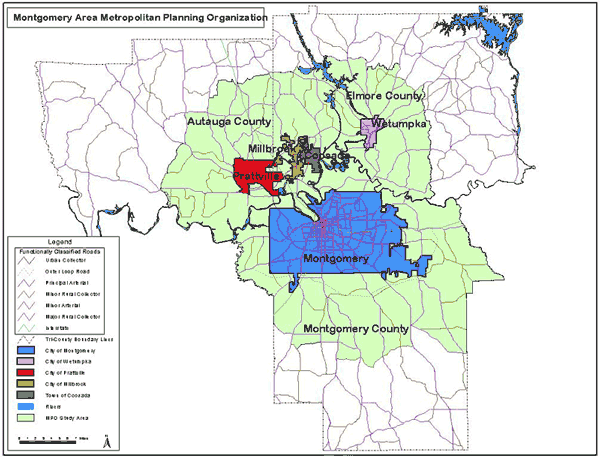
s continuously and contiguously developed at 1,000 persons per square mile) plus contiguous geographic areas likely to become urbanized within 20 years. Portions of Autauga, Elmore, and Montgomery counties along with MPO member municipalities are included in the Montgomery Area Transportation Study Area or MPO Study Area.
The MPO planning staff uses a Geographic Information System (GIS) to develop maps which can be utilized for a variety of purposes. The links below will allow you to view and download maps used in the transportation planning process in the MPO Study Area.
The following documents are in either Adobe pdf format or Microsoft Word. To print or read these files, you will need Adobe Acrobat Reader or the Microsoft Word Viewer.
MPO Area Map
Autauga County General Highway Map
Elmore County General Highway Map
Montgomery County General Highway Map
2002 Montgomery County Traffic Counts
City of Montgomery Traffic Counts (West) 2002
City of Montgomery Traffic Counts (East) 2002
City of Montgomery Traffic Counts (South Central) 2002
City of Montgomery Traffic Counts (North) 2002
City of Montgomery Traffic Counts (Downtown) 2002
2002 Elmore and AutaugaTraffic Counts
Prattville Traffic Counts 2002
City of Millbrook Traffic Counts 2002
Town of Coosada Traffic Counts 2002
City of Wetumpka Traffic Counts 2002
2003 Montgomery County Traffic Counts
Montgomery County Traffic Counts (West) 2003
Montgomery County Traffic Counts (North and East) 2003
City of Montgomery Traffic Counts (West) 2003
City of Montgomery Traffic Counts (East) 2003
City of Montgomery Traffic Counts (North) 2003
City of Montgomery Traffic Counts (Downtown) 2003
City of Montgomery Traffic Counts (Central) 2003
2003 Autauga County Traffic Counts
City of Millbrook and Town of CoosadaTraffic Counts 2003
City of Prattville Traffic Counts 2003
City of Wetumpka Traffic Counts 2003
2003 Elmore County Traffic Counts